

Competence as the key to success
Even in surveying, there are always tasks for which there is no "patent remedy". This complexity can express itself in many different ways. There are usually exceptionally high requirements in one or more areas.
Examples of exceptionally high requirements:
- Accuracy and/or level of detail
- Scope or quantity of work
- Diversity of the task
- Exposed or inhospitable environments
- Suspicion of imminent danger
Consulting
Talking brings people together
A cornerstone of our self-image and a key to success is the competent consulting of our customers. Here we contribute our many years of experience and expertise. In discussion with the client, the task is jointly analyzed and assessed. Because we have all geodetic measuring methods available at AVT, the customer can rely on us to objectively select the best technologies for his task and, if necessary, to combine them.
In the case of the Niklasgalerie, the Imst building district office acted as the client. The task was clearly formulated during the discussion. The special features of this difficult construction site were, in particular, that
- had to be connected to the portal of an existing gallery
- an existing natural tunnel had to be integrated through a rock head
- the historical structure of Finstermünz Fortress had to be taken into account
- the adjacent extremely steep and forested terrain also had to be represented
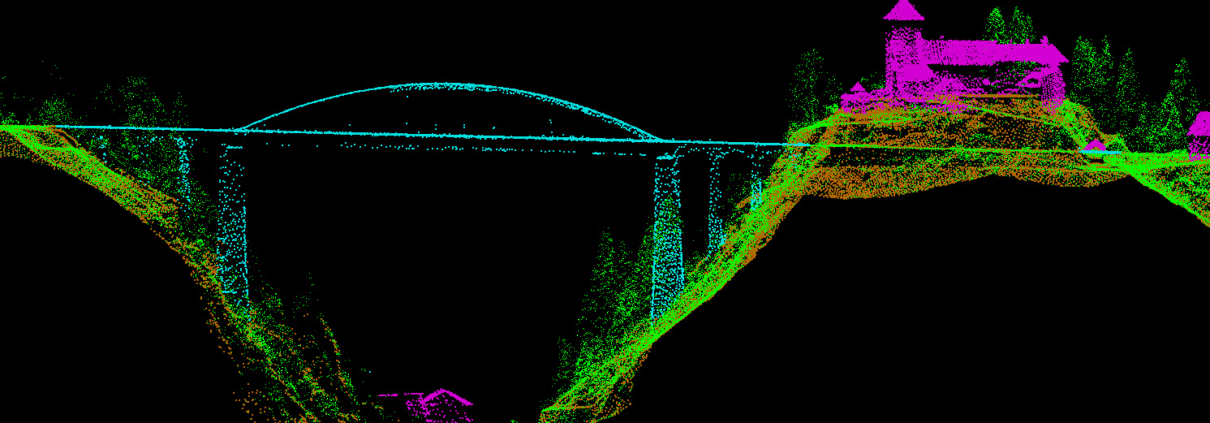
B180-Niklas gallery
With the kind permission of Mr. Ing. Guglberger Günter, Landesbaudirektion Tirol
Concept
Well planned is half solved
We develop the measurement concept based on a jointly compiled specification. In doing so, we are guided by the state of the art, which we reflect through our versatile activities and innovative problem solutions. We look for the most efficient solution to the problem - in terms of the required accuracy and level of detail, the time required and the lowest costs.
In many cases, the concept involves combining different methods and technologies that play to their respective strengths in different aspects of the task at hand.
In the present example of the Niklas Gallery the methods
- Aerial Photogrammetry
- Airborne laser scanning
- Terrestrial laser scanning
- and conventional terrestrial surveying
combined with each other.
This ensured that all areas were covered and, in particular, in the difficult-to-access (partly overhanging) areas and steep slopes, no ascents with elaborate safety measures were necessary.
By using special software, we were also able to display the overhanging rock sections geometrically correctly.
Implementation
Professional and efficient
There are many prerequisites for successful project implementation:
- Professional project management
- Well-trained and motivated employees
- Powerful measuring instruments and software
- Efficient data processing
- Appealing result design
In the case of the Niklas Gallery, ALS data was purchased from the province of Tyrol, a high-precision image flight was carried out, terrestrial laser scanners were used to record the steep areas near the road and the natural tunnel, and conventional measurement methods were used to measure the connecting portal and the control points.
An extremely powerful 3D data set was developed in an appealing time frame, which provided the ideal basis for all subsequent work. Namely, for the derivation of profiles, for the planning of the temporary bypass route, for the planning of the gallery project and, of course, for the stakeout work.